
April 29, 2022
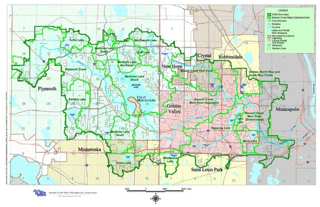
Basset Creek Watershed, image credit Bassett Creek Watershed Management Commission
The Forgotten History of Bassett Creek by John Davenport, HHM Volunteer
To many residents of Minneapolis, Bassett Creek, or Bassett’s Creek, is either unknown or unfamiliar, but has quite an interesting history, going back over 170 years.
The creek’s Dakota name is Ȟaȟá Wakpádaŋ, which can be loosely translated as “Falls Creek.” This name references the connection with the Mississippi River (Haha Wakpa, or “Falls River”) just above St. Anthony Falls (Owámniyomni).
The creek originates at the south end of Medicine Lake. Its shallow stream meanders for 12 miles eastward through Plymouth, Golden Valley, Crystal and Minneapolis, with a large north branch passing down from New Hope, involving many small lakes and swampy areas typical of this urban/suburban landscape.
It runs through Minneapolis on the near north side and defines the border between the Bryn Mawr neighborhood to the south and the Harrison neighborhood to the north. The area was the site of two prosperous businesses in the late 19th century: Fruen Mill and Glenwood-Inglewood Water Company, the latter still operating today, at the northwest end of Bryn Mawr.
THE FIRST BASSETT CREEK DEVELOPER
The creek was named for Joel B. Bassett, who came to Minneapolis in 1850. He established a farm at the mouth of the creek, just below where Plymouth Road now crosses the river, and with capital from several investors, he built a steam-powered sawmill – the first privately owned mill on the west bank. His lumber and flour milling operations lasted until the 1890s.
By 1856 the city had been incorporated with an established street grid, which in turn increased the value of the land. Bassett sold the rest of his property to be platted into city lots.
THE CHALLENGES OF CITY DEVELOPMENT
During this time the city population surged. The growth of the rail and milling industries established near the mouth of the creek resulted in increasingly complex changes in near-north Minneapolis. Railroad tracks and buildings in the area limited the open areas where storm water could be absorbed, creating flooding conditions. The first serious flood occurred in 1903, and another one in 1913 seriously challenged the creek environment, prompting a Minneapolis Tribune article describing the Creek area as “the Venice of Minneapolis.” Even between floods the soft ground was unstable, and residential properties in the North End required filling for stabilization of foundations. The narrow creek valley became “virtually an open sewer,” with accumulated trash and dirt from piecemeal development of commercial and residential areas.
The 1913 flood generated a series of efforts to provide better drainage of the Basset Creek wetlands. The first of these was an underground concrete tunnel, on which construction lasted about 10 years. When completed in 1923, it ran one and a half miles from what is now the west side of the Minneapolis Farmers Market to the creek outlet, where one can see the arch end of the tunnel.
As years passed property development in the area further reduced open areas for storm water to be absorbed into the ground. The underground tunnel was not able to handle the increased creek water flow, which caused a resurgence of flooding from storms and snow-melt. Even up until the late 1970s, the city was still seeking a solution to manage flooding control. One option was to “open” the creek with ponds. This would’ve perhaps made the area more aesthetic, but proved too costly to fully execute.
Drainage problems continued to be logistically challenging as well as socially costly, and involved the displacement of many people who resided in public housing near the creek. It wasn’t until 1992 that a new tunnel (2.4 miles long) was engineered to pass 80 feet under downtown Minneapolis, exiting at the Mill City District just south of St Anthony Falls.
There are many other historical details of environmental and social factors in the evolution of the 39 square mile Bassett Creek watershed and its wetlands. We plan to offer more articles detailing some of the changes in other Hennepin County neighborhoods affected by wetlands.
For more information about the creek, check out the Ȟaȟá Wakpádaŋ / Bassett Creek Oral History Podcast on Spotify, YouTube, or wherever you get your podcasts. Also, HHM helped to create this 2-minute video for “How to Pronounce Ȟaȟá Wakpádaŋ.”
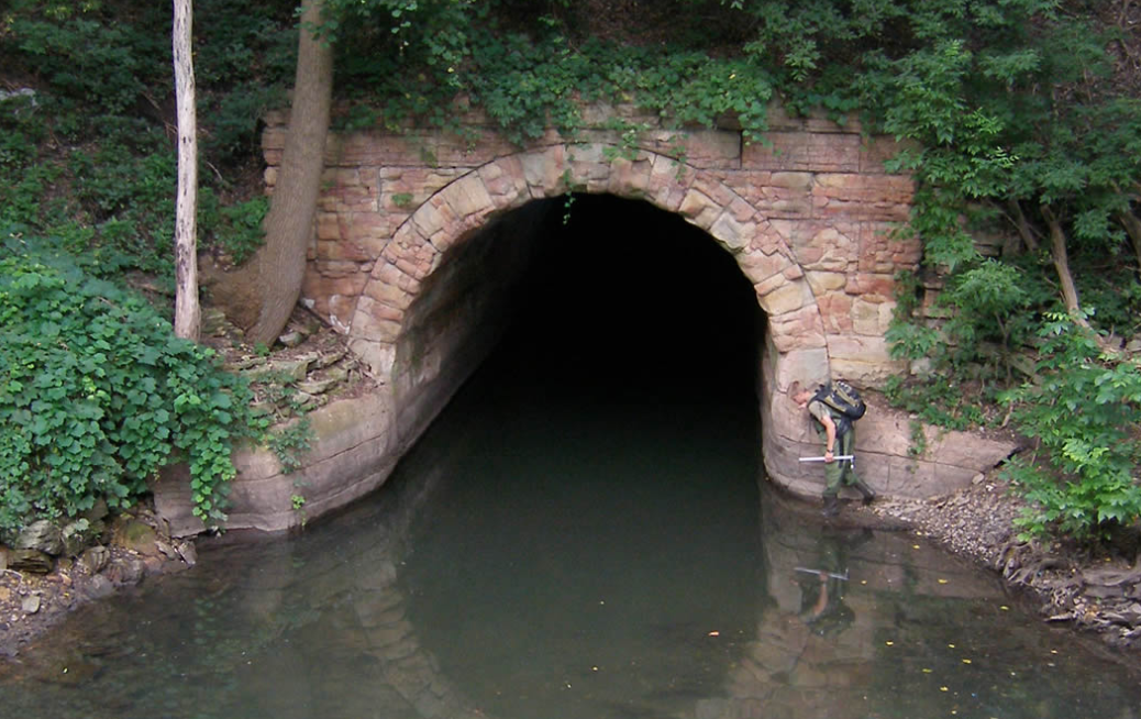
Recent image of Bassett Creek Tunnel outlet completed in 1923, image credit Mississippi Watershed Management Organization
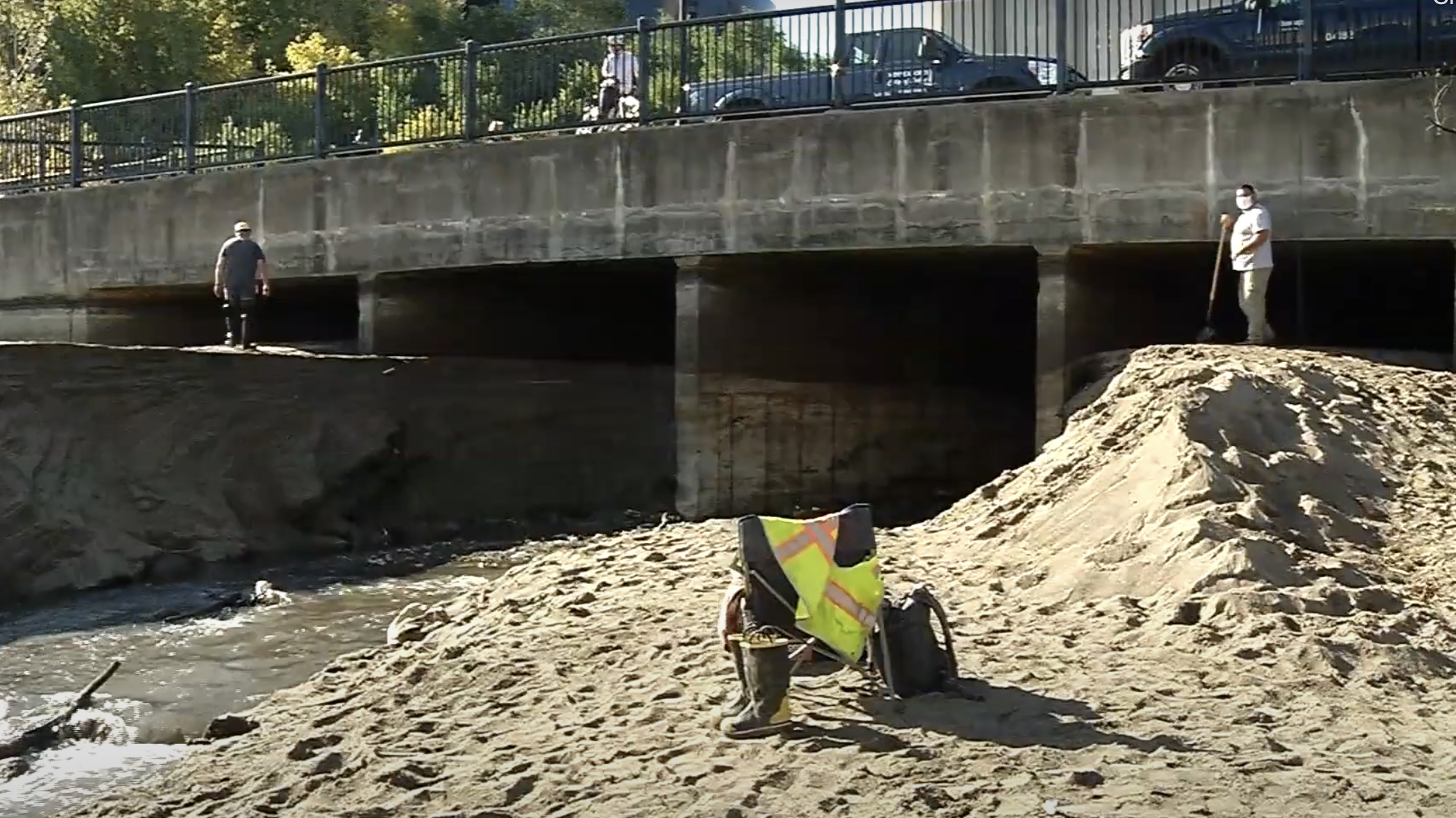
1992 Mill City tunnel outlet, image credit (Screenshot from video) CCX Media Community News
Bassett Creek Time Line
1850 – J.B. Bassett comes to Minneapolis, establishes lumber mill at mouth of creek
1870s – 1880s – Development of North Minneapolis industry, rail yards, housing limits ground for absorption of rainwater, with persistent soft ‘wetland’ property
1903 – 1987: Several severe floods, primarily affecting residential areas, which became locations of poverty housing, physical degradation of creek-bed and accumulation of trash
1923 – First, 1.5 mile tunnel for creek water through north Minneapolis to Mississippi, outlet below Plymouth Ave bridge
1930s -Public housing projects in soft, wetland areas of Sumner Field
1940s – Increasing creek water runoffs from suburban development; water contamination health issues
1960s – I-94 takeover of extensive land areas, further challenging land drainage.
1965 – City report of serious flooding in eastern part of near-north wetlands
1969 – BC Water Management Commission established
1970s – Extensive planning for reconfiguring drainage area by “daylighting” creek flow with water capturing ponds and moving housing; not enacted due to high cost of plan
1980s – more planning for creek channel re-routing
1992 – New tunnel established, running 80 feet under riverfront business-industrial area to mouth at Mill City Ruins
Article Resources
Bassett’s Creek – Mill City Times 2020
Bassett Creek Minneapolis – Hidden Waters Blog 2016
Bassett Creek Valley Master Plan 2007
Exploring the Ghostly Route of Minneapolis’s Underground Bassett’s Creek 2017
Hidden Waterways – Bassett Creek 2021
Mississippi River Drawdown Reveals Bassett Creek Tunnel 2020
The Myth of Bassett’s Creek 2011
Old Minneapolis Tunnel Upgrade 2017
Photo resources
- Bassett Creek Watershed Management Commission:https://web.archive.org/web/
20120722161013/http://www. bassettcreekwmo.org/about.htm# Watershed - Mississippi Watershed Management Organization: https://www.
mwmo.org/planning/old-bassett- creek-tunnel/ - (Screenshot from video) CCX Media Community News:https://youtu.be/aDyOYqHW6NE